READING GRID REFERENCES
What is a grid?
Topographic maps have a system of lines called grid lines on them . These lines form a grid, which consists of vertical and horizontal lines . Each square that is form by these lines is called a grid square.
It is important to note that the vertical lines are called eastings as their value increases towards the east, while the horizontal lines are called northings as their value increases to the north.
What the following video about eastings and northngs.
http://www.screenr.com/mEG
What is grid reference?
A grid reference is a unique value given to each grid square. Grid reference is used to locate points or areas on a map. Students are required to learn to locate areas using 4-figure grid reference and use 6-figure grid reference to locate points in a grid square.
Four Figure Grid Reference
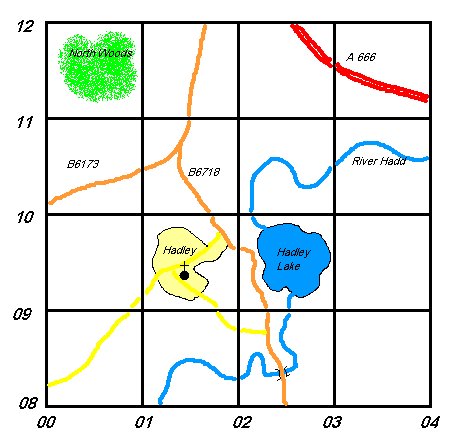
To locate an area using four figure (4 digits) grid reference we need to locate the two sets of eastings numbers and the two sets northings numbers that borders the area.
We then write down the 2 digits that is to the left of the grid square, that is, the lower of the two eastings numbers that border the area. Then we write the the 2 digits to the bottom of the grid square, that is, the lower of the two northings numbers that border the area.
For example Hadley is between eastings 01 and 02. In this case we write down 01, as is is to the left of the Hadley. We then write down northings 09 as it is at the bottom of Hadley.
When put together we have 0109. This is the four figure grid reference for Hadley.
Four Figure Grid Reference
To locate an area using four figure (4 digits) grid reference we need to locate the two sets of eastings numbers and the two sets northings numbers that borders the area.
We then write down the 2 digits that is to the left of the grid square, that is, the lower of the two eastings numbers that border the area. Then we write the the 2 digits to the bottom of the grid square, that is, the lower of the two northings numbers that border the area.
For example Hadley is between eastings 01 and 02. In this case we write down 01, as is is to the left of the Hadley. We then write down northings 09 as it is at the bottom of Hadley.
When put together we have 0109. This is the four figure grid reference for Hadley.
Six Figure Grid Reference
6-figure grid reference gives a more accurate location of a point with a grid square.
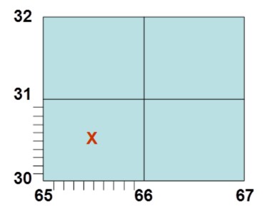
To locate a place using 6-figure grid reference the space between two eastings is divided into 10 equal intervals. Then you would divide the space between the two northings into 10 equal intervals. Each interval or line is 1/10th. The figure to the right shows grid square 6530 divided into 10 vertical intervals and 10 horizontal intervals.
To give the 6-figure for point X, you would count how many tenth (10th) place X is from eastings 65. ( Always remember to count towards the east.) We can see point X is 5/10th of the way from eastings 65. So you write down 655. You then count how many 10th point X is from northing 30. This is also 5/10th away from northing 30. the 6-figure for point X then is written as 655305.
NB. Remember that eatings MUST be given before northings, Also you count towards the east and towards the north.
Click on the following link to play a game which will give you more practice on locating places using 6-figure grid reference.
http://www.echalk.co.uk/Geography/MapReading/gridReferences/gridReferences.html
Video showing 4-figure and 6-figure grid reference. http://www.screenr.com/oEG
